|
"One is always a long way from solving a
problem until one actually has the answer." - Stephen Hawking
Repeat
GIS
Project #2,
however in this application, use the ArcGIS ArcToolbox command Analyst Tool
→ Proximity → Multiple Ring Buffer to generate 20
buffered areas at one mile intervals out to 20 miles from the construction site
and then use the command Analyst Tool
→ Overly → Identity to measure the distances from the
University of Memphis Construction site to each material vendor. Compare the
distances with those measured manually with ArcGIS Measure tool.
Use the
spreadsheet developed GIS Project
#2 to
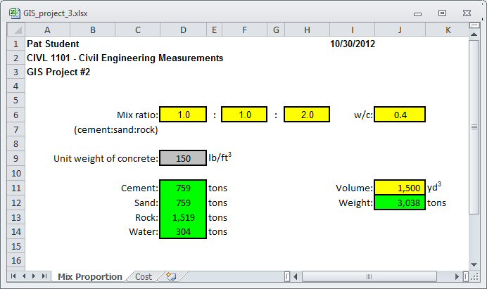
calculation of the total cost of delivered materials. Compute the total cost of delivered materials required to make
1,500 yd3 of concrete with a mix
ratio of 1:1:2 with a w/c ratio of 0.4 (assume that
concrete weight 150 lbs/ft3).
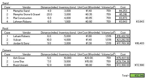
Next, use the ArcGIS concrete material database (Concrete_materials)
to estimate the distance from each material vendor to the Engineering Science
Building (the delivery point) and collect data for unit cost ($/ton/mile) and
inventory volume (tons) for each concrete material. With data for unit cost,
volume, and delivery distance for each material, estimate the minimum delivery
cost for the required concrete materials. The total cost of each delivered
material may be estimated as:
Total Cost ($) = Unit Cost ($/ton/mile) x
Volume (tons) x Distance (miles)
For convenience, vendors require the estimated
delivery distance to be rounded up to the next mile (for example, 5.24 miles is
6 miles). Also, note that if one vendor cannot supply all the material, several
vendors may be used. For simplicity, compute the minimum cost for each material
and then add the results together to estimate the minimum total cost.
This website was originally
developed by
Charles Camp for
CIVL
1101.
This site is
Maintained by the
Department of Civil Engineering
at the University of Memphis.
Your comments and questions are welcomed.
|