|
Longest cathedral-arch bridge in U.S. nears completion by Tony Illia in
Reno, ENR.com, 11/28/2011
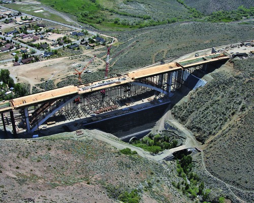
A 1,722-foot-long, 295-foot-tall cathedral-arch bridge in Nevada -- one of the
most expensive projects in the state's history, according to this article -- is
nearly complete. The six-lane Galena Creek Bridge is part of a $600 million
freeway construction project that seeks to connect Reno and Carson City. "This
is a signature project, a showcase of our abilities, and proof that we can
handle a job of this size and complexity," Nevada Department of Transportation
district engineer Thor Dyson said.
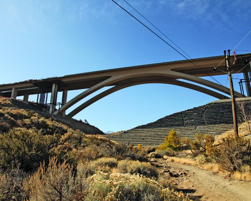
The critics have called it "the bridge to nowhere." It has gone through over a
decade of delays and setbacks. But the 1,722-ft-long, 295-ft-tall Galena Creek
Bridge, one of the costliest, most controversial projects in Nevada's history,
is finally nearing completion.
Crossing a small creek in a rocky, rural patch of northern Nevada about 20 miles
southwest of Reno, it will be both the country's longest cathedral-arch bridge
and the linchpin of a $600-million Interstate 580 extension between Reno and
Carson City.
The 8.5-mile-long, six-lane freeway bypasses a busy, accident-prone stretch of
U.S. Highway 395—which runs through Pleasant Valley, a small, unincorporated
community in Washoe County—that handles 40,000 vehicles daily. Northern Nevada's
most congested rural roadway, the two-lane undivided highway is susceptible to
high winds and head-on collisions.
Nevada Dept. of Transportation (NDOT) officials hope the extension will divert
up to 70% of the traffic away from Pleasant Valley while improving safety,
reducing travel time and bolstering NDOT's reputation.
"This is a signature project, a showcase of our abilities, and proof that we can
handle a job of this size and complexity," says NDOT district engineer Thor A.
Dyson. "Completion of this project is important for the department's psyche."
Locals, however, are sensitive about the freeway's alignment and look. The
project received vociferous feedback from residents and businesses who were
determined to maintain the area's scenic beauty. The freeway, as a result, hugs
the 5,000-ft-tall southern mountain range. The project includes $10 million for
environmentally friendly landscaping and replanting.
"We listened to the community, and they wanted to minimize [the bridge's]
appearance," says Dyson. The unobtrusive appearance, however, entails heavy
engineering that includes nine bridges and 5 million cu yd of tricky excavation.
The high elevation also prompted NDOT to add a $2-million Boschung deicing
system with sensors and deck-embedded nozzles that spray potassium acetate in
four second intervals when the temperature falls below freezing (ENR 1/15/07 p.
24). The system—a first for the state—is being installed on four bridges.
Designed by CH2M Hill Inc., Englewood, Colo., with NDOT, the project includes
three miles of asphalt frontage roads, 26,246 linear ft of mechanically
stabilized earth walls, 14 miles of drainage pipe and 25 miles of concrete
barrier rail. It travels through rugged terrain that required 18 months of
continuous drill-and-shoot blasting. Large dozers, articulating trucks and
backhoes with hammer attachments broke up rock, most of which was re-used. There
were 40 pieces of earthmoving machinery at work at any one time. The biggest
roadway cut, nicknamed "the Matterhorn," required the removal of one million cu
yd of material.
"[The cut] is located in the middle of the freeway alignment, which made hauling
tough," says NDOT resident engineer Brad F. Durski. Fill removal took the
equivalent of 100,000 truckloads, he says.
|