|
Detention Pond Project Description: This project
aims to design a stormwater detention pond on the site assigned to
your group in the lab. The detention pond must provide minimum storage of 50,000 gallons,
meet all design criteria, and minimize the project's total cost. Figure 1
shows the embankment design criteria.
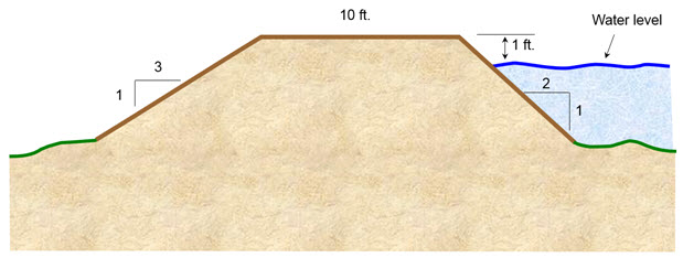
Figure 1. Embankment Design Criteria
The detention design criteria are:
- The maximum side slope of the pond
embankment on the upstream side of the dam (inside the pond) is 1:2
- The maximum side slope of the pond
embankment on the downstream side of the dam (outside the pond) is 1:3
- The crest of the pond
embankment should be 10 ft. wide to accommodate a vehicle.
- The
water level must be at least 1 ft. below the crest of the pond embankment.
- The soil used to construct the
pond embankment must be compacted, and the fill or loose soil volume is reduced by 15% when compacted.
- The side slopes of the pond
embankment must be protected from erosion.
- The pond embankment must have
a spillway not placed on compacted material.
- The minimum
width of the spillway is 10 ft.
Typical costs for materials and services are:
- On-site cut and fill: $2.50/yd.3
- Off-site fill: $5.00/yd.3
- Off-site cut: $3.00/yd.3
- Concrete (delivery and labor):
$100/yd.3
- Pond embankment protection: sod $0.25/ft.2, hydro-seed -
$0.17/ft.2, dry seed $0.10/ft.2,
stone $ 1/ft.2, concrete $ 2/ft.2
These cost estimates are preliminary. Over
time, as additional cost items are required, a current list of costs will be
posted on the class web page. Please keep the proj As additional cost items are
required, a current list of costs will be posted on the class web page over
time. Please check the web page routinely to keep the project's status up to
date. In addition, all supplemental information posted on the web page will be
announced in class.
The detention pond project poses
several challenges to each group: developing an
accurate topographic survey of the site,
designing and configuring the detention pond,
locating the detention pond on the site such
that cut-and-fill is minimized, and developing a
sound engineering solution that meets the design
criteria while reducing the project cost.
The analysis skills required in
this project are topographic computations for
contour maps, traverse computations for
estimating areas, cut-and-fill for the pond and
the embankment, and the configuration of the
pond spillway. Spreadsheets should be developed
to compute information for topographic maps,
traverse areas, and cut-and-fill minimization.
Project Resources:
Groups may seek information about materials and design from: the
UM Civil Engineering faculty (Drs.
Claudio Meier,
David Arellano, and Charles Camp), professional organizations, practicing
engineers, and available publications.
This website was originally
developed by
Charles Camp for
CIVL
1112.
This site is maintained by the
Department of Civil Engineering
at the University of Memphis.
Your comments and questions are welcomed.
|