|
Objective
This assignment aims to use your spreadsheet to develop a feasible detention
pond design for one of the sites assigned to your group in the lab.
This part of the assignment aims to estimate
the cost of cut-and-fill and the detention pond
volume. This application will support your
designs for the
detention
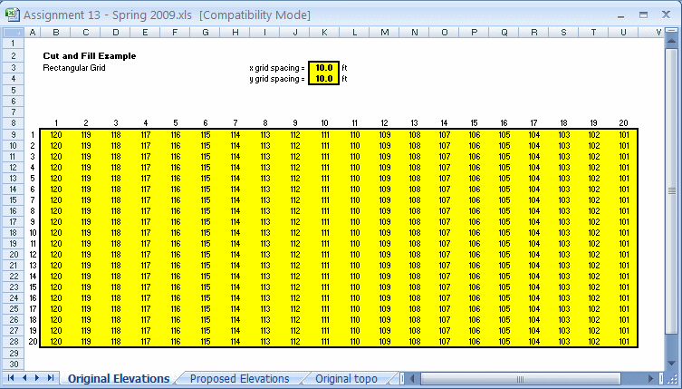
pond project. Your spreadsheet should allow users to enter the row and
column spacing of the elevation grid, the
original elevations at each gridline
intersection, and the proposed elevation. In
addition, your spreadsheet should graph the
original and the proposed elevations. The data
in this table is available in spreadsheet form
by clicking here:
Cut-and-Fill Example data.
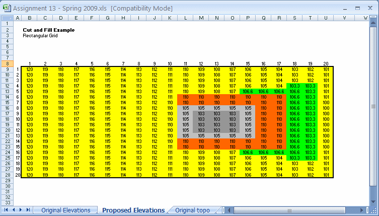
Your proposed elevations should be input on a separate worksheet
in cells corresponding to the original elevations. A set of proposed elevations
for this example problem is shown below. Note that the top of the proposed
detention pond embankment is orange,
the outside slope changes are green, and the
slope changes inside the pond are gray.
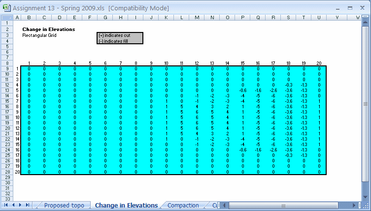
Once you have entered the original and the proposed elevations
at the grid points, subtract the proposed elevations from the original
elevations to compute the change-in-elevation value for each grid point. In this
case, negative (-) values will indicate fill points, and positive (+) values
will indicate cut values.
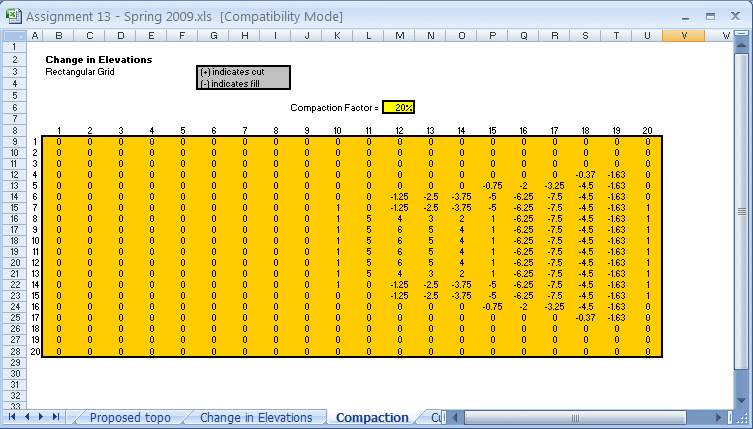
The user should also be able to enter a value for the fill loss
due to compaction. Once the change-in-elevations are computed, adjust the fill
values (negative values) for compaction. Divide the value by (1 - %compaction)
to change each negative change-in-elevation value. The example below divides
each negative change-in-elevation value by 80%. The adjustment for fill
effectively increases the cut volume to balance the required compacted fill
volume.
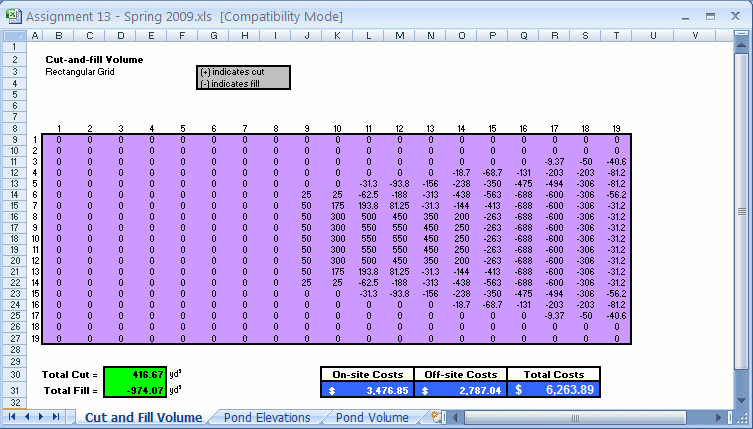
The cut-and-fill volume should be estimated after the change-in-elevation
values have been corrected for compaction. To calculate the value of
cut-and-fill for each grid cell, multiply the average of the four corner
change-in-elevation values by the area of the grid cell [remember negative (-)
area is fill and (+) area is cut]. Sum the cut-and-fill volumes for all the grid
cells to estimate the total cut-and-fill for the entire site. Report if the
cut-and-fill is balanced or if more cut or fill is required to reach the
proposed elevations. Also, compute the total volume of cut and the total volume
of fill needed for the site. All volumes should be reported in cubic yards (yd3).
Next, estimate the cost of the cut-and-fill
earthwork. Recall, on-site cut and fill costs
$2.50 per yd3, off-site fill costs
$5.00 per yd3, and off-site cut costs
$3.00 per yd3. Remember, if the cut
and fill are not balanced, the remaining
material must be removed/brought off-site at the
off-site rate. An estimate for the cut and fill
volumes and the associated earthwork costs using
the data presented in the example is shown
below. Note that the volume calculation results
(in purple)
have one less column and one less row in the
worksheet due to the averaging of adjacent
cells. In other words, four cells in the
proposed elevation worksheet define one volume
cell. The total cut and fill is shown in green
, and the earth costs are in blue.
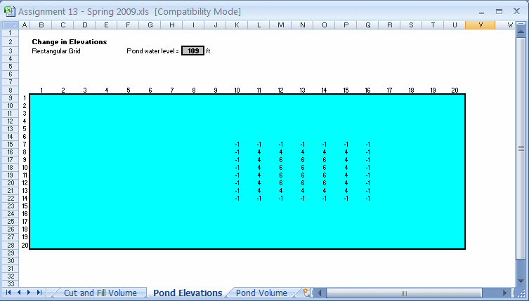
An estimate of the pond volume can be computed like that used in
the can-and-fill volume calculation. First, estimate a pond elevation by
subtracting the proposed elevations from the pond elevation. Inside the proposed
embankment structure, positive (+) values of the difference between the pond
elevation and the proposed elevations indicate that water is detained in the
pond (DP). The DP's negative (-) values suggest that the proposed elevation is
above the pond elevation. The pond volume calculation should ignore the positive
(+) values of DP outside the embankment structure. Using the data presented in
the example above, the values of DP are shown in the worksheet below. Note that
the proposed pond elevation is given in cell I3.
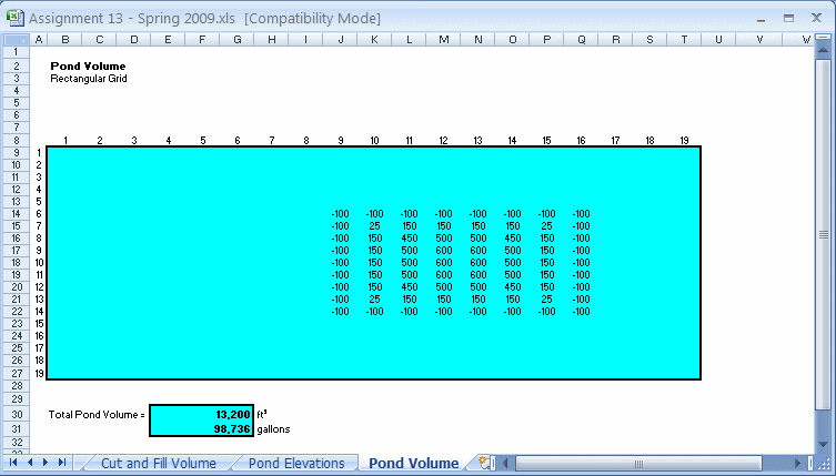
The pond volume for this example is computed in the worksheet shown below.
Note that the volume is calculated in ft3 and converted to gallons (1
ft3 = 7.48 gallons). The positive (+) DP cells outside the proposed
embankment are deleted from the pond volume calculation.
This website was originally
developed by
Charles Camp for
CIVL
1112.
This site is maintained by the
Department of Civil Engineering
at the University of Memphis.
Your comments and questions are welcomed.
|